Descargar la presentación
La descarga está en progreso. Por favor, espere

1
Dirección Meteorológica de Chile
Ciclo ENOS y el Pronóstico Climático para Chile: Nov - Dic Ene 2013 Dirección Meteorológica de Chile

2
Temario Patrones de Circulación Atmosférica y Anomalías
Anomalía de la Precipitación y las Temperaturas (Tmáx - Tmín) III. Ciclo El Niño - La Niña y proyecciones Pronóstico Estacional: Precipitación y Temp. Extremas
 III. Ciclo El Niño - La Niña y proyecciones Pronóstico Estacional: Precipitación y Temp. Extremas.")
3
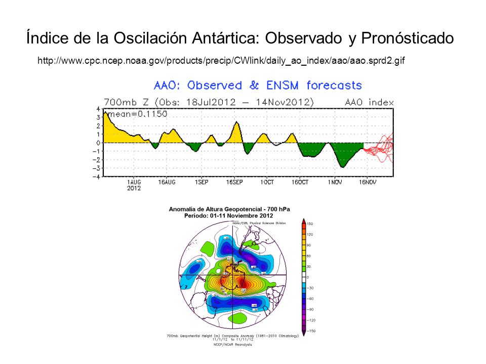
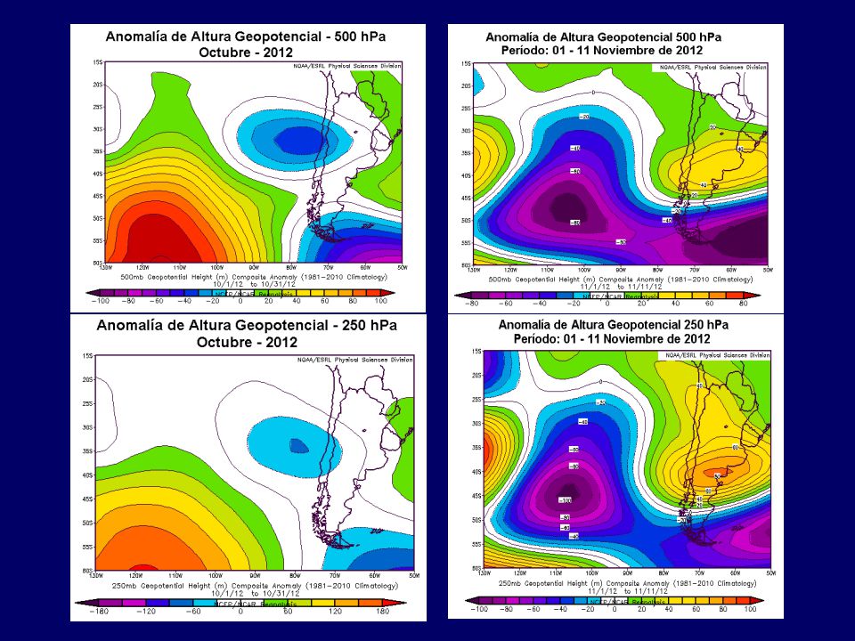
A A La circulación atmosférica durante Octubre de 2012, presentó un anticiclón subtropical intenso, con un núcleo de anomalías anticiclónicas de >6 hPa presente en el Pacífico sur, en 50°S y 110ºW. Anomalías ciclónicas se presentaron en la región de Magallanes, con anomalías de -2 hPa. Un cambio notorio se observó durante la primera mitad de noviembre 2012.

6
Variabilidad Intraestacional - MJO
Análisis P R O N S T I C 12.nov.2012 17.nov.2012 22.nov.2012 27.nov.2012 02.dic.2012 07.dic.2012 12.dic.2012 17.dic.2012 12.dic.2012

7
Actualizado al 14 de Noviembre 2012

9
La actual situación pluviométrica del año 2012, indica que existe un déficit de agua caída en gran parte del país y solo Balmaceda se encuentran levemente sobre lo Normal.

10
IPE (Índice de Precipitación Estandarizado)
1 mes : Octubre -2012 3 meses: Ago Oct. 2012 6 meses: May 2012-Oct 2012

11
12 meses: Nov. 2011-Oct2012 24 meses: Nov. 2010-Oct 2012 Categoría
EXLI: Extremadamente Lluvioso Categoría LI: Lluvioso MLI: Moderadamente Lluvioso N: Normal MS: Moderadamente Seco S: Seco EXS: Extremadamente Seco LLI: Ligeramente Lluvioso LS: Ligeramente Seco 12 meses: Nov Oct2012 24 meses: Nov Oct 2012

12
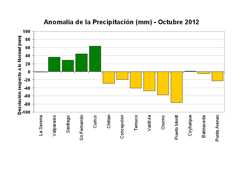
Déficit Pluviométrico
Anomalía pluviométrica (%) Octubre -2012 Anomalía pluviométrica (%) Enero a Octubre -2012
 Octubre Anomalía pluviométrica (%) Enero a Octubre")
13
Temperatura del Aire

14
Las anomalías fueron calculadas respecto del período base

15
Las anomalías fueron calculadas respecto del período base

16
OCTUBRE NOVIEMBRE

17
La Niña 2012 y proyecciones: Indicadores Atmosféricos y Oceanográficos

18
INDICADORES ATMOSFÉRICOS DEL CICLO ENOS
ÍNDICE DE LA OSCILACIÓN DEL SUR DARWIN A TAHITI

19
INDICADORES ATMOSFÉRICOS DEL CICLO ENOS
ÍNDICE DE PRESIÓN - ANTICICLÓN SUBTROPICAL PACÍFICO SUR DARWIN A TAHITI

20
OSCILACIÓN ANTÁRTICA Octubre 2012 Climatología

21
Índice de la Oscilación Antártica: Observado y Pronósticado
22
Pacífico Ecuatorial (2°N-2°S)
Anomalías (ºC) Temp. Superficial del Mar (ºC) Temp. Subsuperficial del Mar (ºC) (0-300 m) 2011 2012
 Temp. Superficial del Mar (ºC) Temp. Subsuperficial del Mar (ºC) (0-300 m)")
23
VIENTOS ALISIOS Intensidad Media (m/s) Anomalía (m/s) 2011 2012
 Anomalía (m/s)")
24
ANOMALÍAS DE LA TEMPERATURA SUBSUPERFICIAL DEL MAR
OCÉANO PACÍFICO ECUATORIAL 05 Septiembre Noviembre 2012

25
Evolución del contenido de Calor en el Pacífico ecuatorial

26
ANOMALIA DE LA TEMPERATURA SUPERFICIAL DEL MAR (°C)
SEMANA: Noviembre 2012

27
Pronóstico Estacional de la TSM
Área Niño 3.4

28
ENSO-neutral is favored through the Northern Hemisphere winter 2012-13
(08 Noviembre 2012). CLIMATE PREDICTION CENTER/NCEP/NWS and the International Research Institute for Climate and Society Both Pacific and Indian oceans neutral BUREAU OF METEOROLOGY – AUSTRALIA EVOLUÇÃO DO FENÔMENO EL NIÑO DESACELERA SOBRE O PACÍFICO EQUATORIAL 15 Noviembre 2012 CPTEC -BRASIL The SSTs in the equatorial central-eastern Pacific will be slightly warmer than normal, but the warm signal is weakened than that in the last forecast 25 Octubre 2012 APCC - COREA
. CLIMATE PREDICTION CENTER/NCEP/NWS. and the International Research Institute for Climate and Society. Both Pacific and Indian oceans neutral. BUREAU OF METEOROLOGY – AUSTRALIA. EVOLUÇÃO DO FENÔMENO EL NIÑO DESACELERA SOBRE O PACÍFICO EQUATORIAL. 15 Noviembre CPTEC -BRASIL. The SSTs in the equatorial central-eastern Pacific will be slightly warmer than. normal, but the warm signal is weakened than that in the last forecast. 25 Octubre APCC - COREA.")
29
Pronóstico Estacional de Temp. Extremas y Precipitación
Trimestre: Nov - Dic Ene 2013

30
Modelación Estadística

31
P33 = Percentil 33 de limite inferior del rango Normal
P66 = Percentil 66 del límite superior del rango Normal P50 = Precentil 50 Valor esperado en el trimestre NDE (mm)
")
32
PRONÓSTICO ESTACIONAL DE LA TEMPERATURA MÁXIMA

33
PRONÓSTICO ESTACIONAL DE LA TEMPERATURA MÍNIMA

34
Modelación Dinámica

35
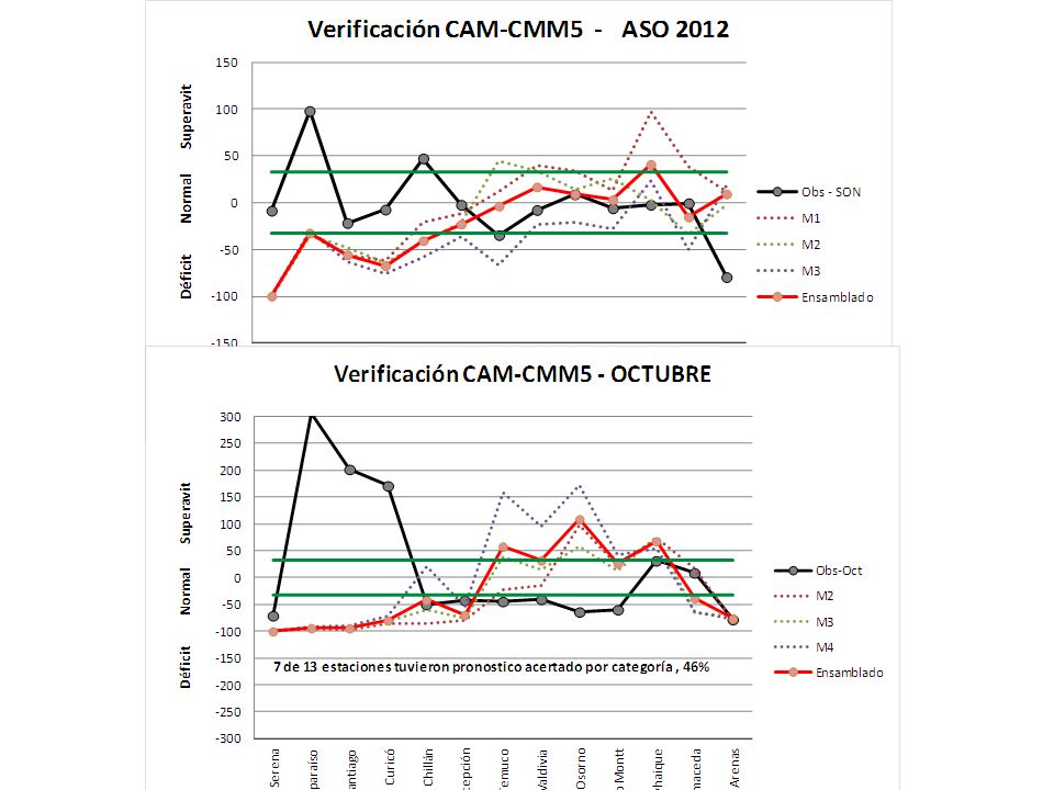
Pronóstico de total de precipitación mensual ASO – Modelo Dinámico CMM5
CAM-OLE2-DMC Miembro 3 Enero 13 Diciembre 12 Características: Dominio 2 (30 km res), Clim.: CRU, TSM de octubre 2012 Noviembre12
, Clim.: CRU, TSM de octubre Noviembre12.")
37
Pronóstico de Anomalías de Precipitación SON – Modelo Dinámico CMM5
CAM-OLE2-IDEAM-DMC Miembro 3 Noviembre 12 Diciembre 12 Enero 13 Características: Dominio 2 (30 km res), Clim.: CRU, TSM de octubre 2012
, Clim.: CRU, TSM de octubre")
39
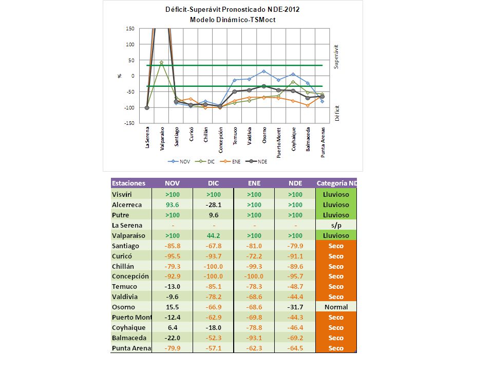
Pronostico NDE- Precipitación
All models Confiabilidad NDE- Precipitación

40
Pronostico NDE- Temperatura 850
Confiabilidad NDE- Temperatura 850

41
POAMA (Australia) NCEP (EEUU) COLA (EEUU)
 NCEP (EEUU) COLA (EEUU)")
42
IRIF (EEUU) MSC_CANCM4 (Canadá) BBC (China)
 MSC_CANCM4 (Canadá) BBC (China)")
43
HMC (Rusia) GDAPS_F (Korea)
 GDAPS_F (Korea)")
44
PRONÓSTICO CLIMÁTICO NDE 2012-2013
Las perspectivas climáticas para Chile durante el trimestre Nov - Dic 2012 – Ene 2013 son las siguientes: Precipitación: La precipitación acumulada para el trimestre Nov-Dic Ene2013, en la zona del norte del altiplano de Chile, se presentará con precipitaciones Bajo lo Normal. La región central y sur, espera precipitaciones en torno a lo Normal. La región austral, espera precipitaciones Sobre lo Normal. Temperaturas Máximas y Mínima Medias: La temperatura máxima se presentará en torno a sus valores normales, en la zona norte de Chile. En la zona central y sur, se presentará con temperaturas por sobre lo Normal. En la zona austral, se presentará con temperaturas entre Normal y Bajo lo Normal. La Temperatura mínima, se presentará por sobre lo Normal, en la zona norte y central del país. La zona sur y austral, espera temperaturas mínimas en torno a lo Normal.

45
Gracias

Presentaciones similares


 Ciudad de Guatemala,>")


 Y APLICACIONES AGROMETEOROLÓGICAS PARA LOS PAISES DEL MERCOSUR Campinas,>")


