Descargar la presentación
La descarga está en progreso. Por favor, espere

1
EROSION HIDRICA

2
EROSION “Erosion es un proceso de movilización y transporte de partículas por agentes erosivos.” Ellison, 1944 Agentes erosivos Impacto de gotas de lluvia Flujo superficial del agua de lluvia por escurrimiento

3
EROSION ES UN PROBLEMA PORQUE:
Degrada el suelo Reduce la productividad del suelo Reduce el contenido de materia orgánic Remueve nutrientes para las plantas Causa sedimentation aguas abajo Produce sedimentación de contaminantes Some of the reasons why we are concerned about erosion.

4
DONDE PUEDE SER UN PROBLEMA LA EROSION HIDRICA
Bajos resíduos de cultivos Labranza Convencional Surcos a favor de la pendiente Pasturas mala mantenidas Situations where erosion is likely to be greatest. In general, erosion is greatest is vegetative cover, including residue from last’s year crop, is low and where operations are directly up and down slope.

5
IMPACTO DE LA GOTA DE LLUVIA

6
MOVILIZACION Movilización Carga de Sedimento Tansporte de Sedimento
Suelo Detachment is the removal of sediment from the soil. Detachment adds sediment to the sediment load. Sediment load is the amount of soil being transported.

7
DEPOSICION Carga de Sedimento Transporte de Sedimento Deposición Suelo
The amount of sediment being transported is known as sediment load. Deposition is the transfer of sediment from the sediment load to the soil surface. Deposition causes sediment load to decreases and sediment to accumulate on the soil surface.

8
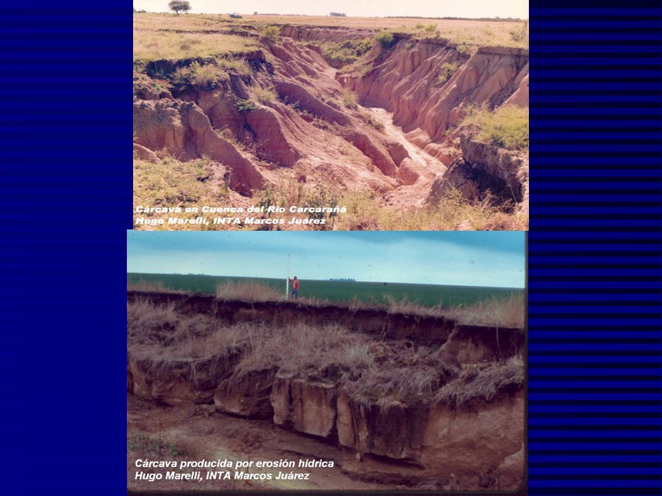
TIPOS DE EROSION Laminar o mantiforme Surcos Cárcavas
RUSLE2 estimates interrill and rill erosion, sometimes referred to as sheet-rill erosion. Other procedures must be used to estimate the other types of erosion. Ephemeral gullies reoccur in the same location, rills are parallel and generally do not reoccur in the same location.

9
EROSION LAMINAR INCIPIENTE

10
EROSION LAMINAR PARCIAL

11
EROSION LAMINAR INCIPIENTE

12
EROSION LAMINAR GENERALIZADA

13
EROSION EN SURCOS

14
EROSION EN SURCOS DOMINANTE

15
EROSION EN SURCOS GRAVE

16
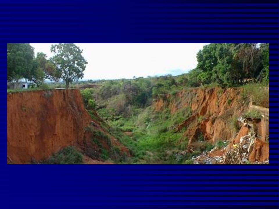
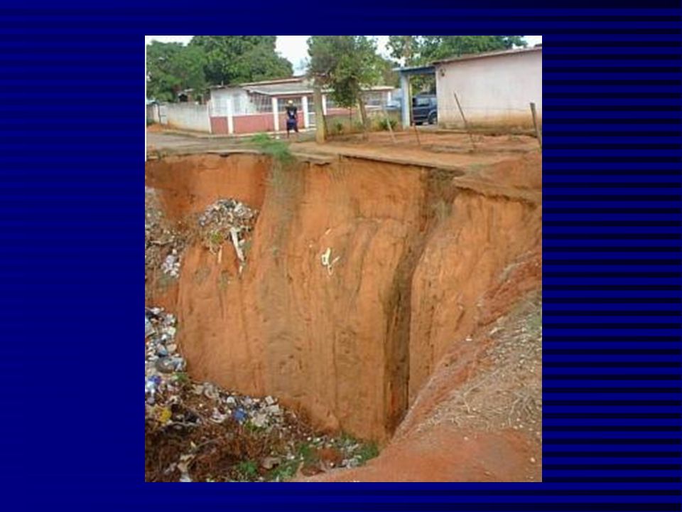
CARCAVA INDIVIDUAL

17
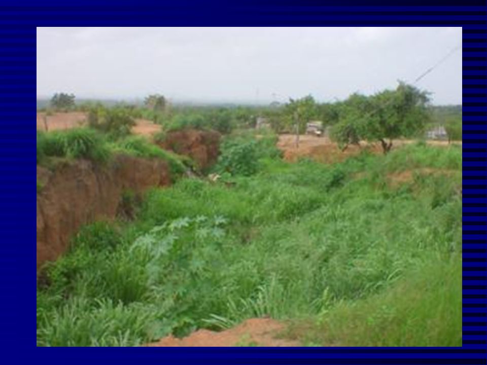
SISTEMA GENERALIZADO DE CARCAVAS

22
FORMACION Y CONTROL DE CARCAVAS

23
ETAPAS DE EVOLUCION DE UNA CARCAVA

24
Metodología para medir el crecimiento en tres dimensiones de una cárcava (USDA)
R = (5,25 x 10⁻⁵ ) A0,46 P0,20 Donde: R = Avance en m de la cabeza de la cárcava en un período determinado. A = Area en m² de la cuenca aguas arriba de la cárcava. P = Total anual de las lluvias de 24 horas de duración mayores o iguales a 12,7 mm.
 A0,46 P0,20. Donde: R = Avance en m de la cabeza de la cárcava en un período determinado. A = Area en m² de la cuenca aguas arriba de la cárcava. P = Total anual de las lluvias de 24 horas de duración mayores o iguales a 12,7 mm.")
25
TECNICAS DE CONTROL DE CARCAVAS. Cárcavas más anchas que profundas

26
Cárcavas más profundas que anchas

27
Taludes de piedras

28
Colocación de barreras para disminuir el movimiento del agua

29
INTRODUCCION AL USO DE LA RUSLE2 (Revised Universal Soil Loss Equation-Version 2)
Dónde se aplica RUSLE2 Factores que afectan la erosion Factores de RUSLE2 Fundamentos de RUSLE2

30
Paisaje Tipos de Erosion RUSLE2 Area Escurrimiento Entresurcos Surcos
Cárcavas (Concentrated flow) This slide shows the portion of the landscape where interrill-rill (sheet) erosion may occur. The dashed lines on the left show the RUSLE area that is depicted in the upper right hand corner of the screen and the dashed line on the left side represents a subwatershed divide for a the two concentrated flow watersheds. Tipos de Erosion
 This slide shows the portion of the landscape where interrill-rill (sheet) erosion may occur. The dashed lines on the left show the RUSLE area that is depicted in the upper right hand corner of the screen and the dashed line on the left side represents a subwatershed divide for a the two concentrated flow watersheds. Tipos de Erosion.")
31
ZONA DE MEDICION DE RUSLE
PERDIDA DE SUELO CANTIDAD DE SEDIMENTO RUSLE2 ESTIMA HASTA AQUI The simplest application of RUSLE2 is to assume a simple uniform slope. RUSLE2 estimates the amount of sediment leaving the slope length assumed in the RUSLE2 computation. Soil loss is the net mass of sediment removed from a particular portion of the slope. In this simple uniform slope, sediment yield, which is the amount of sediment delivered to the end of the slope equals soil loss. If deposition, like the deposition that occurs on concave slopes had occurred, sediment yield would have been less than soil loss. Soil loss is expressed in unit of mass divided by the area that produced the soil loss.

32
FACTORES QUE AFECTAN LA EROSION EN SURCOS Y ENTRESURCOS
Clima Suelos Topografía Uso del suelo Practicas Culturales Practicas de Control Erosion is greatest where rainfall amount and intensity are highest. Some soils are naturally more erodible than are other soils. Steep and long slopes produce more erosion than do short and flat slopes. Land use has a huge effect on erosion. Exposing the soil to raindrop and surface runoff dramatically increases erosion.

33
FACTORES DE LA RUSLE2 (Pérdidas diarias) a = r k l s c p
Factores diarios r - Lluvias/Escurrim. k – Erodabilidad Suelo l – Long. pendiente s – Grado de pendiente c – Manejo de cobertura p – Practicas de control The USLE computed soil loss by A=RKLSCP, where an average annual value was computed for each factor. With the exception of the interaction between the R factor and the C factor, not interaction between the USLE factors were considered. The temporal scale used in computing the C factor was a crop stage period over which cover-management conditions were assumed to be represented by an average value for the period. The length of crop stage periods typically ranged from a few days, like the rough plowed period in the spring, to a few months, like the after harvest period over the late fall, winter, and early spring. RUSLE1 considered additional interactions of the K and R factors and a partial interaction between P and R. Also, the temporal time scale used in RUSLE1 was half month, and less if an operation occurred within a half month. This approach allowed a “paper version” of RUSLE1 to be used. However, while the mathematical techniques used in USLE and RUSLE1 were powerful and allowed paper versions, they were mathematically inaccurate by about 15 to 20% in several situations. The proper mathematical procedure is to compute a daily value for each factor, compute a daily soil loss value, and add up the daily values to obtain a value for rotation. RUSLE2 uses this mathematical procedure, which is a major change from both the USLE and RUSLE1. Although RUSLE2 computes an average annual value for the traditional USLE/RUSLE1 factors, those values are not used to compute soil loss. In fact, multiplication of those values, as was done in the USLE and RUSLE1, will not give the RUSLE2 soil loss value. The difference results from the far more proper mathematics in RUSLE2 than in the approximate mathematics in the USLE/RUSLE1. Small letters, rather than the traditional capitol letters, are used to distinguish the RUSLE2 approach from the USLE/RUSLE1 mathematical approach. The convention is that upper case letters in the USLE and RUSLE1 indicate average annual values while the lower case letters in RUSLE2 indicate daily values. Erosión anual promedio = suma de valores diarios

34
FACTORES de RUSLE (Producción de Sedimento)
Clima r Suelo k Topografía ls Uso y manejo lscp del suelo In agricultural situtations, climate, soil, and topography are determined by the location and are fixed. However, ls can be changed by installing terraces. On severely disturbed areas, both soil and topography can be changed. The most important consideration in conservation planning and the factor that has the single greatest effect on soil loss is land use, management, and the use of supporting practices like contouring. C also affects soil by changes in organic matter, random roughness and consolidation.

35
FACTORES RUSLE A = f (erodabilidad, erosividad) Erosividad – rklscp
Erodabilidad - klc Erosivity is a measure of the forces actually applied to the soil by the erosive agents of raindrop impact, waterdrops falling from plant canopy, and surface runoff. Erosivity has two parts. The inherent erosivity determined by the rainfall at a location and the infiltration of the soil based on inherent soil properties. The other part of erosivity is the part that management can change such as changes in infiltration that affects rate and amount of runoff and the present of material that reduces the forces applied to the soil. Erodibility is a measure of the susceptibility(inverse of resistance) of the soil to erosion. Erodibility has two parts, the inherent erodibility of the soil and the part of the erodibility that can be influenced by management. Notice that most RUSLE2 factors contain both an erosivity effect and an erodibility effect. Erosivity is a function of climate and management.
 of the soil to erosion. Erodibility has two parts, the inherent erodibility of the soil and the part of the erodibility that can be influenced by management. Notice that most RUSLE2 factors contain both an erosivity effect and an erodibility effect. Erosivity is a function of climate and management.")
36
Capacidad de transporte
Relación entre deposición, capacidad de transporte y carga de sedimento en una pendiente compleja Pendiente Capacidad de transporte Cap. transporte = carga de sedimento Carga de sedimento Producción de sedimentos menor que la capacidad de transporte This slide illustrates the interaction of transport capacity, sediment load, sediment production, and deposition on a complex slope. Main points: If transport capacity exceeds sediment load, sediment load will be determined by the amount of sediment made available by detachment. If sediment load exceeds the amount of sediment produced by detachment, deposition occurs. If the sediment load exceeds transport capacity because of a decrease in transport capacity, deposition occurs which reduces sediment load. When deposition occurs, sediment loads “lags” transport capacity depending on the fineness of the sediment. Deposition is a selective process where the coarse particles are deposited leaving the sediment load enriched in fines. In this illustration, local deposition occurs on the very flat portion of the hillslope because interrill erosion produces more sediment than the flow can transport. Deposition occurs on the lower end of the slope because of a decrease in transport capacity because of a flattening of the slope. Deposition begins to occur where transport capacity equals sediment load. Deposition does not necessarily begin to occur just where transport capacity begins to decease. Deposición Deposición debido a que la producción de sedimento excede la capacidad de transporte

37
Deposición, Capacidad de Transporte y Carga de Sedimento para una franja de pasto
Región de Depositación Capacidad de Transporte Depositacion termina donde la capacidad de transporte = carga de sedimento Carga de sedimento This slide illustrates how RUSLE2 computes deposition for a grass strip. The strip causes an abrupt decrease in transports capacity at the upper edge of the strip. After the abrupt decrease, transport capacity increases within the strip. Deposition occurs because transport capacity drops to less than sediment load. If the strip is sufficiently wide, deposition will end within the strip where sediment load becomes equal to transport capacity. Porción de suelo erosionable Pasto denso

38
APLICACIONES DE LA RUSLE
Cultivos Pasturas Pastizales Tierras forestales Sitios de construcción Areas de producción minera Areas de entrenamiento militar Parques Areas de deposición de residuos

39
Factores de la RUSLE2 r- factor erosionabilidad k- factor erodibilidad
l- factor longitud de pendiente s- factor grado de pendiente c- factor manejo de cobertura p- factor practicas de control The next few slides will give a brief overview of RUSLE.

40
EROSIVIDAD Tormentas simples Suma de valores diarios
Energía x intensidad en 30 minutos Fundamentalmente producto de lluvia x intensidad Suma de valores diarios Promedio de promedios anuales Datos diarios = promedio anual x fracción que ocurre en un deerminado día SE USAN VALORES EI DE 10 AÑOS The core part of RUSLE2 is that it estimates soil loss from an individual storm. The linear relationship between erodibility and soil erodibility allow simple mathematical approaches to integrate the variables over time.

41
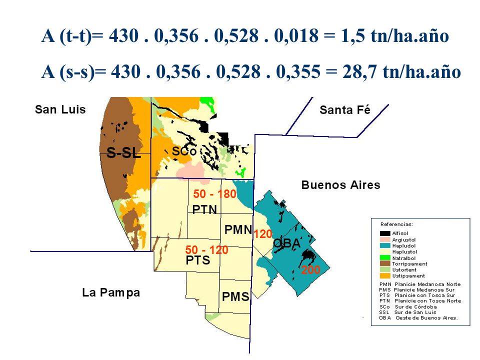
EROSIVIDAD - R Las Vegas, NV 8 Phoenix, AZ 22 Denver, CO 40
Syracuse, NY 80 Minneapolis, MN 110 Chicago, IL 140 Richmond, VA 200 St. Louis, MO 210 Dallas, TX 275 Birmingham, AL 350 Charleston, SC 400 New Orleans, LA 700 Erosivity varies greatly by location. Climate is about 100 times more erosive in New Orleans than in Las Vegas.

42
A (t-t)= , , ,018 = 1,5 tn/ha.año A (s-s)= , , ,355 = 28,7 tn/ha.año 120 200
43
ERODABILIDAD DEL SUELO - K
Medida en una parcela estandar 22 m de largo, 9% pendiente, sin cobertura, labranza a favor de pendiente Independiente del manejo Factores principales Textura, materia organica, estructura, permeabilidad A key point is that soil erodibility is determined under the standard reference condition where management effects have been eliminated by maintaining the unit plots in a continuous tilled, fallow conditions for a number of years. The K value that is used if for the soil fines, but the influence of rock fragments in the soil profile should be considered in setting K values. The effects of rock fragments on the soil surface is considered in the cover-management computations. Do not use a K value that has been adjusted for rock fragments on the soil surface because use of such an adjusted K value can cause a major mathematical error in RUSLE2. RUSLE2 computes a time varying K value as a function of monthly temperature and rainfall. In contrast to RUSLE1, the time varying K value can be used throughout the US except in the Northwest Wheat and Range Region (NWRR).
.")
44
TOPOGRAFIA Longitud de la pendiente Porción de pendientes erosionables
GRado de pendiente Forma de la pendiente These are the main variables that determine how topography affects erosion.

45
FORMA DE LA PENDIENTE Convexa Uniforme Compleja-Convexa:concava
These are typical hillslope shapes. Even though the hillslope is non-uniform, a uniform hillslope is often assumed in RUSLE2 to compute soil loss on the upper eroding portion of the hillslope. Such as approach is often satisfactory for most conservation planning. However, in some cases like concave:convex hillslope, the entire hillslope needs to be considered to obtain an accurate soil loss estimate. Even though deposition occurs on the midpart of this hillslope, the entire hillslope length has to be considered because of the origin of the runoff that flows over the lower portion. RUSLE2 can be used to compute soil loss, deposition, and deposition for each of these slope shapes by dividing the slope into segments. Compleja-Convexa:concava Compleja-Concava:convexa Concava

46
USO DEL SUELO Manejo de cobertura Prácticas de control
Two factor reflect the influence of land use in RUSLE2. These factors are for cover-management and supporting practices. Conservation practices are based on either cover-management and/or supporting practices. Referring to supporting practices as conservation practices is improper. No-till is a wonderful conservation practice that works entirely though cover-management effects.

47
Manejo de cobertura Comunidad de vegetación Cultivo Rotación
Labranza conservacionista Aplicación de material en superficie o enterrado (resíduos, abonos) Aumento de la rugosidad superficial Cover-management is used in a variety of ways for erosion control and conservation practices.b
 Aumento de la rugosidad superficial. Cover-management is used in a variety of ways for erosion control and conservation practices.b.")
48
Practicas de control Curvas de nivel Cultivos en Franjas Terrazas
Buffer, filtro, cultivos en contorno, barreras Terrazas Endicamientos Drenajes Supporting practices are primarily related to practices that affect transport capacity of runoff.

49
Curvas de nivel Pérdida de suelo Pérdida de Suelo Deposición remota
This slide illustrates the deposition that is caused by dense strips of grass. This deposition is remote deposition because it occurs some distance from where the sediment was detached. Soil loss also occurs at several locations on the slope. Even though deposition occurs, the surface runoff continue through the depositional area. Soil loss on the lower part of the slope depends on runoff that originated from the very upper end of the slope. Two distinct rates of soil loss occur on this slope. A high soil loss occurs on the the “clean-tilled” area and a low soil loss occurs in the grass strips below where deposition ends within the strips. Sediment Yield = Soil Loss - Deposition

50
Curvas de nivel con Siembra Directa. Marcos Juárez.

51
FRANJAS BUFFER

52
CURVAS DE NIVEL, GUATRACHE, LA PAMPA

53
TERRAZAS DE DRENAJE deposición Deposición Pérdida de Suelo
This slide illustrates the remote deposition that occurs with a terrace system. Soil loss occurs on the inter-terrace interval. Soil loss on the inter-terrace interval is less than soil loss without the terraces because terraces shorten up the slope length. Runoff on the lower inter-terrace interval originates at the next terrace upslope, not from the very top of the hillslope. The deposition that occurs in the terrace channels is remote deposition because the location of the deposition is some distance from where the sediment was detached. Also, the deposition is concentrated in a much smaller area than the area that produced the sediment. Sediment Yield = Soil Loss from Inter-terrace interval – Deposition in terrace Sedimento erosionado

54
TERRAZAS DE ABSORCION deposición Deposición Pérdida de Suelo
This slide illustrates the remote deposition that occurs with a terrace system. Soil loss occurs on the inter-terrace interval. Soil loss on the inter-terrace interval is less than soil loss without the terraces because terraces shorten up the slope length. Runoff on the lower inter-terrace interval originates at the next terrace upslope, not from the very top of the hillslope. The deposition that occurs in the terrace channels is remote deposition because the location of the deposition is some distance from where the sediment was detached. Also, the deposition is concentrated in a much smaller area than the area that produced the sediment. Sediment Yield = Soil Loss from Inter-terrace interval – Deposition in terrace Infiltración

55
Types of Terraces Gradient terrace Contour line
Sediment basin into underground tile line Gradient terrace have uniform grade along them. Spacing varies with gradient terraces because of nonuniform topography. Generally discharge into grassed waterway to get runoff down slope without causing ephemeral gully erosion Grade nonuniform along parallel terraces. Have to be careful to avoid grade along parallel terraces being too steep. Sediment basins usually used in conjunction with parallel terraces. Typically discharge into underground tile line. Main purpose of both systems is runoff management to control excessive rill erosion and especially ephemeral gully erosion. Parallel terrace Grassed waterway Gradient terrace

56
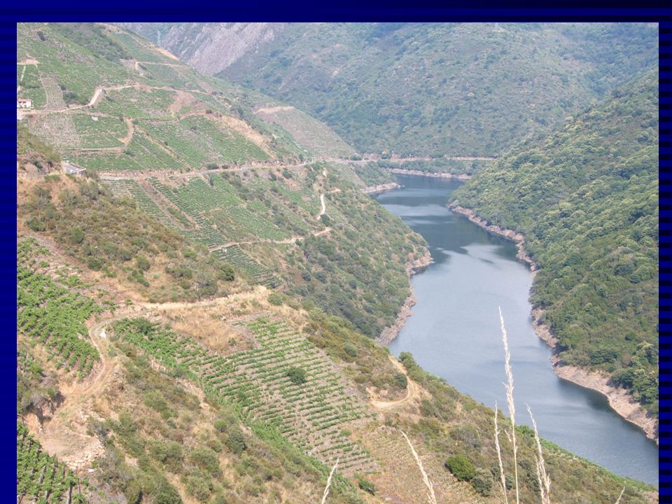
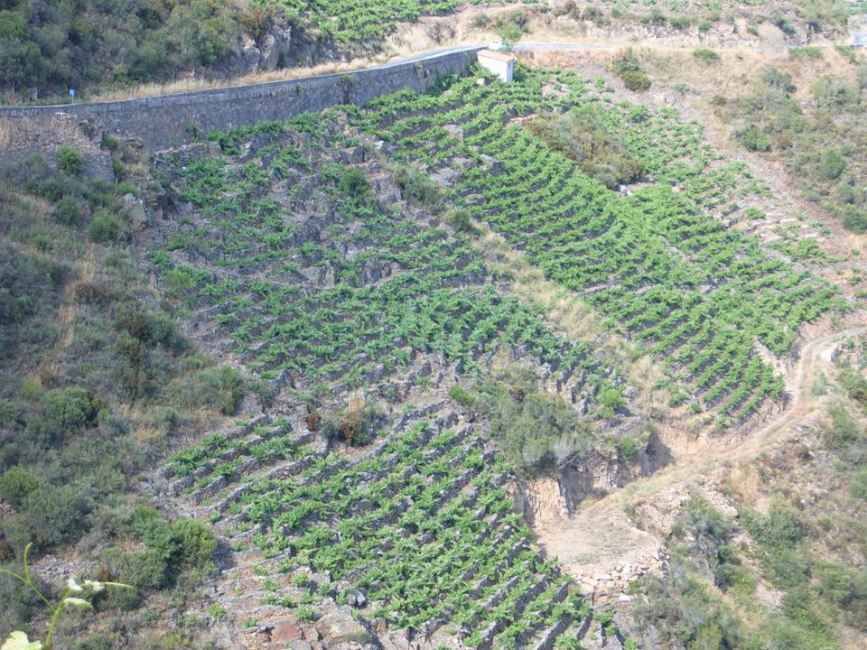
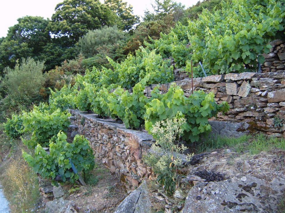
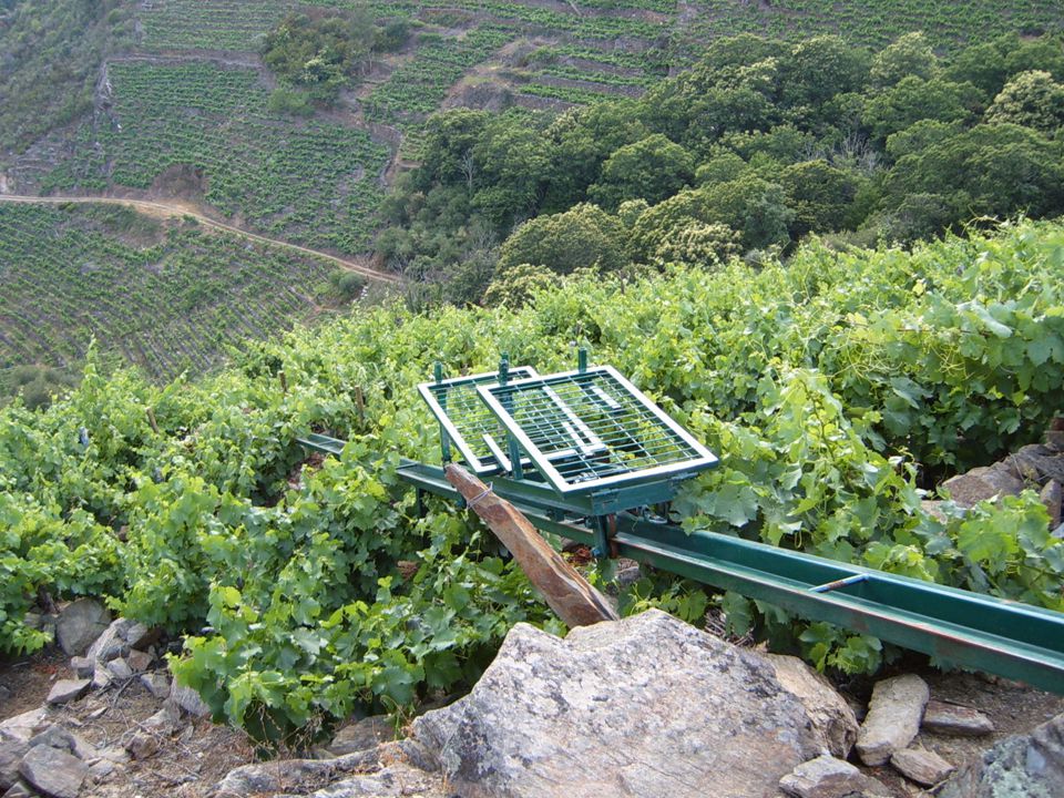
Terrazas absorción. Río Sil, España

Presentaciones similares


 en agregados.>")


 Sergio Velásquez M. Curso Internacional Gestión de Cuencas Julio de 2006.>")