Descargar la presentación
La descarga está en progreso. Por favor, espere

1
G.R.A.S.P Chile Miguel Fernández Díaz

2
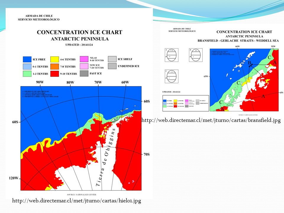
Durante el año se ha continuado desarrollando nuevos productos, entre los que se destaca los incorporados por el Servicio Meteorológico de la Armada de Chile. Desarrollo de la adaptabilidad modelos atmosférico WRF Elaboración de mapas de hielo marino

3
The Global Maritime Distress and Safety System (GMDSS) Services
LIMITS OF METAREAS (to enlarge map)
")
5
Simulacion del modelo WRF V3.3.1.
Dominio anidado con resolucion espacial de 3 km. Zona entre la IV y VI region de Chile (31.96S-74.06W; 31.90S-70.73W; 34.39S-74.06W; 34.33S-70.61W) . Simulaciones corridas 2 veces al da (0 y 12 UTC) para el perodo comprendido entre el 1o de agosto y el 30 de noviembre del Cada simulación realiza pronósticos hasta 72h con un intervalo de 3h.
 . Simulaciones corridas 2 veces al da (0 y 12 UTC) para el. perodo comprendido entre el 1o de agosto y el 30 de. noviembre del Cada simulación realiza pronósticos hasta 72h con un. intervalo de 3h.")
6
Validación Realizada con 4 estaciones navales: Dos automaticas (datos cada 10 minutos) Dos convencionales (datos cada 3 horas) Valparaso: 33.01S W Faro Punta Panul, San Antonio: 33.56S W Variables analizadas: Temperatura a 2 metros (T2), Presion Supercial (PSFC), Intensidad del viento y comp. zonal y meridional (U10 y V10) del viento a 10 metros.
, Presion Supercial (PSFC), Intensidad del viento y comp. zonal y meridional (U10 y V10) del viento a 10 metros.")
7
Preprocesamiento

8
Raiz del Error Cuadratico Medio (RMSE). Correlacion.
Validación Raiz del Error Cuadratico Medio (RMSE). Correlacion. Cuociente entre desviación estandar. > 1 modelo esta sobrestimando la amplitud < 1 modelo esta subestimando la amplitud BIAS. > 0 modelo esta sobrestimando < 0 modelo esta subestimando Skill Score. > 0 mejor el modelo < 0 mejor la persistencia
. Correlacion. Cuociente entre desviación estandar. > 1 modelo esta sobrestimando la amplitud. < 1 modelo esta subestimando la amplitud. BIAS. > 0 modelo esta sobrestimando. < 0 modelo esta subestimando. Skill Score. > 0 mejor el modelo. < 0 mejor la persistencia.")
9
Resultados Viento: Intensidad
arriba: Estaciones Convencionales, abajo: Estaciones Automáticas izq.: Est. Faro Panul, der.: CENMETEOVALP.

10
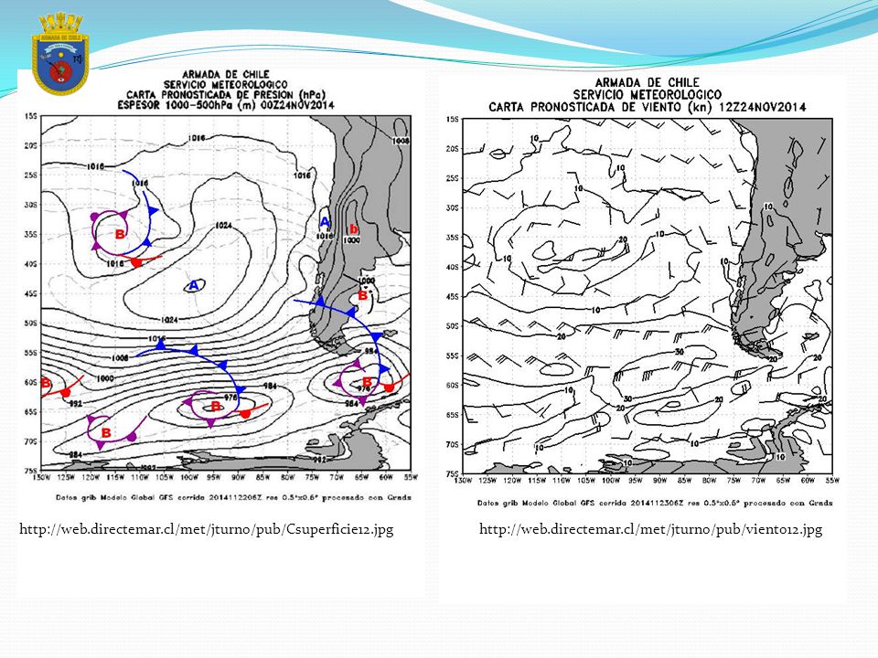
Valparaíso : http://web.directemar.cl/met/jturno/pub/wrf/meteo.jpg
Puerto Montt : Punta Arenas:

12
GOBERNACIÓN MARÍTIMA DE PUNTA ARENAS
CENTRO METEOROLÓGICO DE MAGALLANES INFORME GLACIOLÓGICO BASES TERRITORIO ANTÁRTICO CHILENO FECHA: 26 NOVIEMBRE 2014 – BAHIA FILDES. (CALETA ARDLEY) LAT: 62°13´S LONG: 58°49´W OPERATIVO. ACCESIBLE. HIELOS: 05 TEMPANITOS. 02/10 ESCOMBROS SECTOR COSTERO. – BAHIA CHILE.(BASE PRAT) LAT: 62°29´S LONG: 59°41´W OPERATIVO. ACCESIBLE. HIELOS: 01 TEMPANITO SECTOR SUR. - ESTRECHO INGLES LAT: 62°25´S LONG: 59°39´W OPERATIVO. ACCESIBLE. HIELOS: 01 TEMPANITO. - PASO LAUTARO. LAT: 62°23´S LONG: 59°43´W OPERATIVO. ACCESIBLE. HIELOS: SIN HIELOS. - ENSENADA IQUIQUE LAT: 62°28´30"S LONG: 59°39´30"W OPERATIVO. ACCESIBLE. HIELOS: 02/10 HIELO FIJO EN SECTOR NORESTE DEL MUELLE. OPERATIVO. – RADA COVADONGA (BASE O´HIGGINS) LAT: 63°18´9"S LONG: 57°54´55"W OPERATIVO. HIELOS: a) EXTERIOR RADA COVADONGA, OPERATIVO. b) SITUACION INTERIOR RADA COVADONGA. CABO LEGOUPIL A ISLA KOPAITIC (Paso Coloma):01 TEMPANITOS 02 GRUÑONES. 01/10 ESCOMBROS. ISLA KOPAITIC A ISLOTE GÁNDARA : 2 GRUÑONES. 01/10 ESCOMBROS. ISLOTE GÁNDARA A ISLOTE BARRIOS : 1 TEMPANITO. 01/10 ESCOMBROS. ISLOTE BARRIOS A PUNTA ROSS : 2 TEMPANITO. 5 GRUÑONES. 02/10 ESCOMBROS. ENSENADA UNWIN : 2 TEMPANITO. 5 GRUÑONES. 03/10 ESCOMBROS. c) MUELLE RADA COVADONGA : DESARMADO NO OPERATIVO. DESEMBARCADERO : OPERATIVO. – BAHIA PARAISO (BASE GABRIEL GONZALEZ VIDELA) LAT: 64°52´S LONG: 62°54´W A.- BAHIA PARAISO. B.- ACCESO NORTE: OPERATIVO ACCESO SUR: OPERATIVO C.- ACCESO NORTE: ACCESIBLE ACCESO SUR: ACCESIBLE D.- 1) ACCESO NORTE CANAL AGUIRRE CERDA: -02/10 DE ESCOMBROS 2)- CALETA GLORIA: -02/10 DE ESCOMBROS 3)- CANAL AGUIRRE CERDA: - 02 TEMPANOS TAMAÑO PROMEDIO 80 MTS DE LARGO X 04 MTS DE ALTO - 02/10 DE ESCOMBROS 4.- ACCESO SUR CANAL AGUIRRE CERDA: -03/10 DE ESCOMBROS 5.- BAHIA PARAISO: -01 TEMPANO TAMAÑO PROMEDIO 60 MTS DE LARGO X 02 MTS DE ALTO -02/10 DE ESCOMBROS E.- OPERATIVO
 LAT: 62°13´S LONG: 58°49´W. OPERATIVO. ACCESIBLE. HIELOS: 05 TEMPANITOS. 02/10 ESCOMBROS SECTOR COSTERO. – BAHIA CHILE.(BASE PRAT) LAT: 62°29´S LONG: 59°41´W OPERATIVO. ACCESIBLE. HIELOS: 01 TEMPANITO SECTOR SUR. - ESTRECHO INGLES LAT: 62°25´S LONG: 59°39´W OPERATIVO. ACCESIBLE. HIELOS: 01 TEMPANITO. - PASO LAUTARO. LAT: 62°23´S LONG: 59°43´W OPERATIVO. ACCESIBLE. HIELOS: SIN HIELOS. - ENSENADA IQUIQUE LAT: 62°28´30 S LONG: 59°39´30 W OPERATIVO. ACCESIBLE. HIELOS: 02/10 HIELO FIJO EN SECTOR NORESTE DEL MUELLE. OPERATIVO. – RADA COVADONGA (BASE O´HIGGINS) LAT: 63°18´9 S LONG: 57°54´55 W OPERATIVO. HIELOS: a) EXTERIOR RADA COVADONGA, OPERATIVO. b) SITUACION INTERIOR RADA COVADONGA. CABO LEGOUPIL A ISLA KOPAITIC (Paso Coloma):01 TEMPANITOS 02 GRUÑONES. 01/10 ESCOMBROS. ISLA KOPAITIC A ISLOTE GÁNDARA : 2 GRUÑONES. 01/10 ESCOMBROS. ISLOTE GÁNDARA A ISLOTE BARRIOS : 1 TEMPANITO. 01/10 ESCOMBROS. ISLOTE BARRIOS A PUNTA ROSS : 2 TEMPANITO. 5 GRUÑONES. 02/10 ESCOMBROS. ENSENADA UNWIN : 2 TEMPANITO. 5 GRUÑONES. 03/10 ESCOMBROS. c) MUELLE RADA COVADONGA : DESARMADO NO OPERATIVO. DESEMBARCADERO : OPERATIVO. – BAHIA PARAISO (BASE GABRIEL GONZALEZ VIDELA) LAT: 64°52´S LONG: 62°54´W A.- BAHIA PARAISO. B.- ACCESO NORTE: OPERATIVO ACCESO SUR: OPERATIVO C.- ACCESO NORTE: ACCESIBLE ACCESO SUR: ACCESIBLE D.- 1) ACCESO NORTE CANAL AGUIRRE CERDA: -02/10 DE ESCOMBROS 2)- CALETA GLORIA: -02/10 DE ESCOMBROS 3)- CANAL AGUIRRE CERDA: - 02 TEMPANOS TAMAÑO PROMEDIO 80 MTS DE LARGO X 04 MTS DE ALTO - 02/10 DE ESCOMBROS 4.- ACCESO SUR CANAL AGUIRRE CERDA: -03/10 DE ESCOMBROS 5.- BAHIA PARAISO: -01 TEMPANO TAMAÑO PROMEDIO 60 MTS DE LARGO X 02 MTS DE ALTO -02/10 DE ESCOMBROS E.- OPERATIVO.")
Presentaciones similares


>")


 del NCEP (National Center for Environmental Prediction) en el período comprendido entre.>")


