Descargar la presentación
La descarga está en progreso. Por favor, espere

1
MONITOREO CLIMATICO Y PERSPECTIVAS SERVICIO NACIONAL DE METEOROLOGIA E HIDROLOGIA DEL PERU DIRECCION REGIONAL DE PIURA Dra. Ninell Dedios Mimbela Piura-Peru Dirección Regional de Piura

2
Resùmen Condiciones oceano – atmosferica Tendencias Componente Hidrologico Componente Agrometeorologico Proyeccion

3
During January-February 2013, below-average SSTs were observed over the eastern half of the Pacific. Recently, SSTs have been near-average across much of the equatorial Pacific. Recent Evolution of Equatorial Pacific SST Departures ( o C) Longitude Time
 Longitude Time.")
4
Niño Region SST Departures ( o C) Recent Evolution The latest weekly SST departures are: Niño 4 0.0ºC Niño 3.4 -0.3ºC Niño 3 -0.2ºC Niño 1+2 -0.9ºC
 Recent Evolution The latest weekly SST departures are: Niño 4 0.0ºC Niño ºC Niño ºC Niño ºC")
5
COMPORTAMOENTO DE LAS REGIONES NIÑO

6
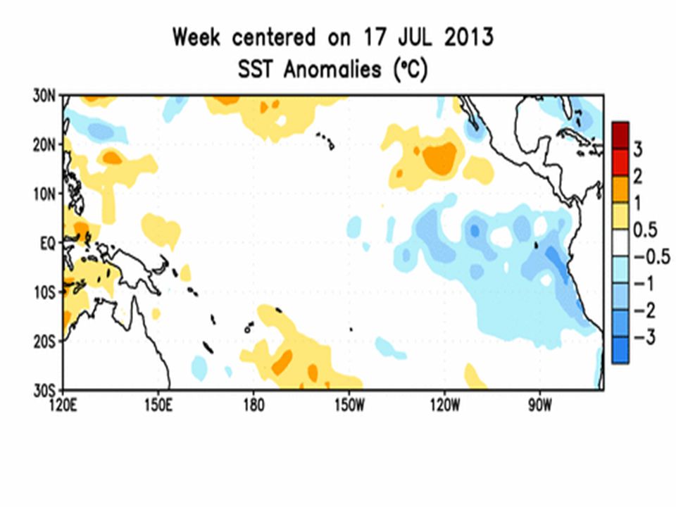
SST Departures ( o C) in the Tropical Pacific During the Last 4 Weeks During the last 4-weeks, equatorial SSTs were above average in the far western Pacific, below average in the eastern Pacific, and near-average elsewhere.
 in the Tropical Pacific During the Last 4 Weeks During the last 4-weeks, equatorial SSTs were above average in the far western Pacific, below average in the eastern Pacific, and near-average elsewhere.")
7
Global SST Departures ( o C) During the last four weeks, equatorial SSTs were below average in the eastern Pacific Ocean and Atlantic Ocean, while above average SSTs were located in the far western Pacific.
 During the last four weeks, equatorial SSTs were below average in the eastern Pacific Ocean and Atlantic Ocean, while above average SSTs were located in the far western Pacific.")
8
Weekly SST Departures ( o C) for the Last Four Weeks During the last month, negative SST anomalies weakened in the eastern Pacific Ocean, while positive SST anomalies persisted in the western Pacific. Over the last month, positive changes in SST anomalies were observed in the eastern equatorial Pacific.

11
Weekly Central & Eastern Pacific Upper-Ocean (0- 300 m) Average Temperature Anomalies Subsurface temperatures were above-average from April – November 2012, and below average during December 2012 – May 2013. From June – September 2013, subsurface temperature anomalies were positive. Currently, subsurface temperatures are near average.

12
Oceanic Niño Index (ONI) The ONI is based on SST departures from average in the Niño 3.4 region, and is a principal measure for monitoring, assessing, and predicting ENSO. Defined as the three-month running-mean SST departures in the Niño 3.4 region. Departures are based on a set of improved homogeneous historical SST analyses (Extended Reconstructed SST – ERSST.v3b). The SST reconstruction methodology is described in Smith et al., 2008, J. Climate, vol. 21, 2283-2296.) Used to place current events into a historical perspective NOAA’s operational definitions of El Niño and La Niña are keyed to the ONI index.
. The SST reconstruction methodology is described in Smith et al., 2008, J. Climate, vol. 21, ) Used to place current events into a historical perspective NOAA’s operational definitions of El Niño and La Niña are keyed to the ONI index..")
13
NOAA Operational Definitions for El Niño and La Niña El Niño: characterized by a positive ONI greater than or equal to +0.5ºC. La Niña: characterized by a negative ONI less than or equal to - 0.5ºC. By historical standards, to be classified as a full-fledged El Niño or La Niña episode, these thresholds must be exceeded for a period of at least 5 consecutive overlapping 3-month seasons. CPC considers El Niño or La Niña conditions to occur when the monthly Niño3.4 OISST departures meet or exceed +/- 0.5°C along with consistent atmospheric features. These anomalies must also be forecasted to persist for 3 consecutive months.

14
Historical El Niño and La Niña Episodes Based on the ONI computed using ERSST.v3b NOTE (Mar. 2012): The historical values of the ONI have slightly changed due to an update in the climatology. Please click here for more details on the methodology: Historical ONI Values Highest El Niño ONI Value Lowest La Niña ONI Value JJA 1951 – DJF 1951/52 1.2ASO 1949 – JAS 1950 -1.4 DJF 1952/53 – JFM 1954 0.8SON 1950 – JFM 1951 -0.8 MAM 1957 – JJA 1958 1.8AMJ 1954 − NDJ 1956/57 -1.7 OND 1958 – FMA 1959 0.6AMJ 1964 – DJF 1964/65 -0.8 MJJ 1963 – JFM 1964 1.4JJA 1970 – DJF 1971/72 -1.3 AMJ 1965 – MAM 1966 1.9AMJ 1973 – JJA 1974 -2.0 JAS 1968 – DJF 1969/70 1.1SON 1974 – MAM 1976 -1.7 AMJ 1972 – FMA 1973 2.1ASO 1983 – DJF 1983/84 -0.9 ASO 1976 - JFM 1977 0.8SON 1984 – ASO 1985 -1.1 ASO 1977 – JFM 1978 0.8AMJ 1988 – AMJ 1989 -1.9 AMJ 1982 – MJJ 1983 2.2ASO 1995 – FMA 1996 -0.9 JAS 1986 – JFM 1988 1.6JJA 1998 – FMA 2001 -1.7 AMJ 1991 – MJJ 1992 1.6OND 2005 – FMA 2006 -0.9 ASO 1994 – FMA 1995 1.2JAS 2007 – MJJ 2008 -1.5 AMJ 1997 – MAM 1998 2.4OND 2008 – FMA 2009 -0.8 AMJ 2002 – JFM 2003 1.3JJA 2010 – MAM 2011 -1.5 JJA 2004 – DJF 2004/05 0.7ASO 2011 – FMA 2012 -1.0 ASO 2006 – DJF 2006/07 1.0 JJA 2009 – MAM 2010 1.6
: The historical values of the ONI have slightly changed due to an update in the climatology. Please click here for more details on the methodology: Historical ONI Values Highest El Niño ONI Value Lowest La Niña ONI Value JJA 1951 – DJF 1951/52 1.2ASO 1949 – JAS DJF 1952/53 – JFM SON 1950 – JFM MAM 1957 – JJA AMJ 1954 − NDJ 1956/ OND 1958 – FMA AMJ 1964 – DJF 1964/ MJJ 1963 – JFM JJA 1970 – DJF 1971/ AMJ 1965 – MAM AMJ 1973 – JJA JAS 1968 – DJF 1969/70 1.1SON 1974 – MAM AMJ 1972 – FMA ASO 1983 – DJF 1983/ ASO JFM SON 1984 – ASO ASO 1977 – JFM AMJ 1988 – AMJ AMJ 1982 – MJJ ASO 1995 – FMA JAS 1986 – JFM JJA 1998 – FMA AMJ 1991 – MJJ OND 2005 – FMA ASO 1994 – FMA JAS 2007 – MJJ AMJ 1997 – MAM OND 2008 – FMA AMJ 2002 – JFM JJA 2010 – MAM JJA 2004 – DJF 2004/05 0.7ASO 2011 – FMA ASO 2006 – DJF 2006/ JJA 2009 – MAM")
15
Recent Pacific warm (red) and cold (blue) episodes based on a threshold of +/- 0.5 o C for the Oceanic Nino Index (ONI) [3 month running mean of ERSST.v3b SST anomalies in the Nino 3.4 region (5N-5S, 120-170W)]. For historical purposes El Niño and La Niña episodes are defined when the threshold is met for a minimum of 5 consecutive over-lapping seasons. The complete table going back to DJF 1950 can be found by clicking: Historical ONI ValuesHistorical ONI Values YearDJFJFMFMAMAMAMJMJJJJAJASASOSONONDNDJ 2002-0.20.00.10.30.50.70.8 0.91.21.3 20031.10.80.40.0-0.2-0.10.20.4 2004 2005 2006 2007 2008 2009 2010 2011 2012 2013 2014 2015 2016 2017 2018 2019 2020 2021 2022 2023 2024 2025 2026 2027 0.3 0.20.1 0.2 0.3 0.50.70.8 0.7 0.6 0.4 0.3 0.20.1 0.0 -0.2-0.5-0.8 -0.9-0.7-0.5-0.3 0.00.1 0.2 0.30.5 0.81.0 0.70.3-0.1 -0.2-0.3 -0.4-0.6-0.8-1.1-1.2-1.4 -1.5 -1.2 -0.9 -0.7 -0.5 -0.3 -0.2 -0.1 -0.2 -0.5 -0.7 -0.8 -0.7-0.5 -0.2 0.2 0.4 0.5 0.6 0.8 1.1 1.4 1.6 1.3 1.0 0.6 0.1-0.4-0.9-1.2-1.4-1.5 -1.4-1.2-0.9-0.6-0.3 -0.2 -0.4 -0.6-0.8 -0.9-0.6 -0.5 -0.3-0.2 0.0 0.1 0.4 0.5 0.6 0.2-0.3 -0.6 -0.4 -0.2 -0.3
![Recent Pacific warm (red) and cold (blue) episodes based on a threshold of +/- 0.5 o C for the Oceanic Nino Index (ONI) [3 month running mean of ERSST.v3b SST anomalies in the Nino 3.4 region (5N-5S, W)].](http://images.slideplayer.es/8/2458845/slides/slide_15.jpg "For historical purposes El Niño and La Niña episodes are defined when the threshold is met for a minimum of 5 consecutive over-lapping seasons. The complete table going back to DJF 1950 can be found by clicking: Historical ONI ValuesHistorical ONI Values YearDJFJFMFMAMAMAMJMJJJJAJASASOSONONDNDJ")
16
CPC/IRI Probabilistic ENSO Outlook (updated 5 September 2013) ENSO-neutral is favored through the Northern Hemisphere winter 2013-14.
 ENSO-neutral is favored through the Northern Hemisphere winter")
17
Pacific Niño 3.4 SST Outlook Figure provided by the International Research Institute (IRI) for Climate and Society (updated 18 September 2013). Most models predict ENSO-neutral (-0.5ºC to +0.5ºC) continuing through Northern Hemisphere spring 2014.
 continuing through Northern Hemisphere spring")
18
SST Outlook: NCEP CFS.v2 Forecast Issued 4 October 2013 The CFS.v2 ensemble mean (black dashed line) predicts ENSO-neutral conditions (warm side of neutral) through spring 2014.
 predicts ENSO-neutral conditions (warm side of neutral) through spring 2014.")
19
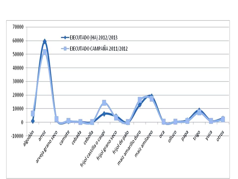
PRONOSTICO TRIMESTRAL PRONOSTICO TRIMESTRAL

22
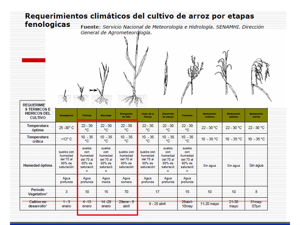
PANORAMA AGROMETEOROLOGICO

25
EVALUACIÓN DE LA HUMEDAD EN EL MES DE SEPTIEMBREZONALUGARES CONDICION DE HUMEDAD OBSERVACIONTumbes La Cruz Déficit Precipitaciones ausentes CañaveralDéficit Valle de Piura San Miguel Déficit Chusis Bernal Miraflores Valle Chira La Esperanza Déficit Alto Piura MallaresDéficit PartidorDéficit ChulucanasDéficit MorropónDéficit MalacasíDéficit LanconesDéficit Sierra Piurana ChalacoDeficitario Precipitaciones muy dispersas a ausentes Sondorillo HuancabambaAdecuado AyabacaAdecuadoAdecuado Salala HuarmacaAdecuado

27
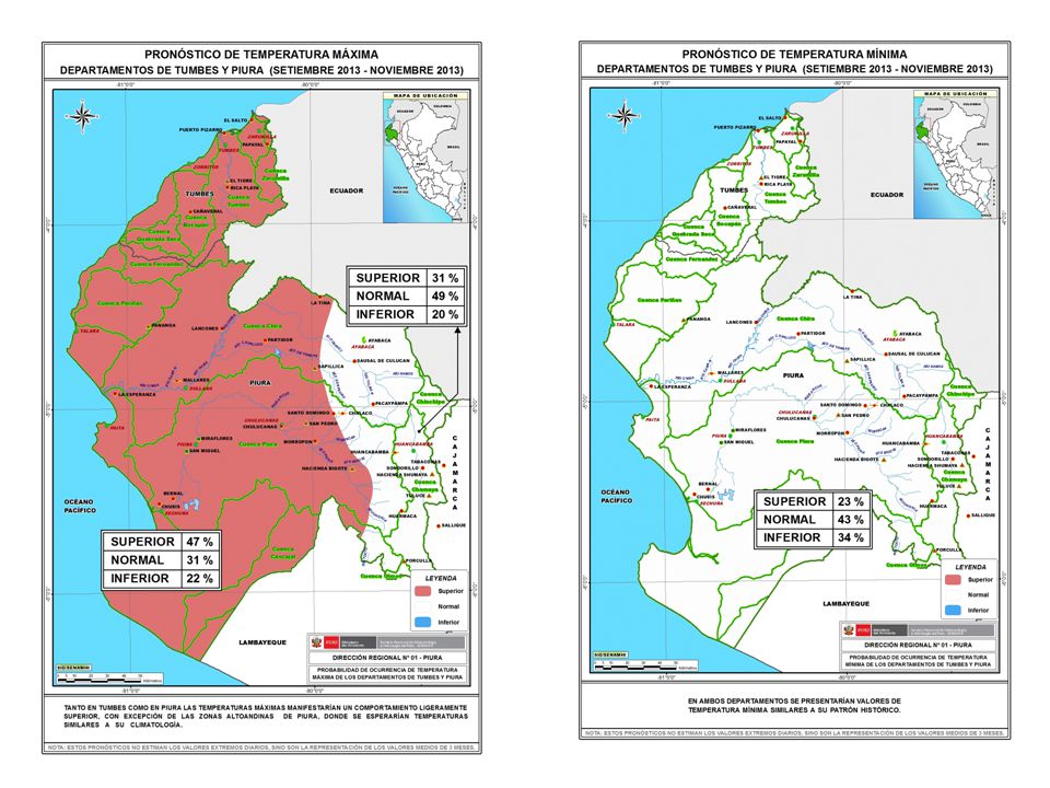
CONDICIONES DE LOS CULTIVOS EN LOS PRINCIPALES VALLES DE LAS REGI Ó NES PIURA Y TUMBES Mango Aunque durante los días 10 y 11 de septiembre se registraron días críticos para el cultivo debido a que se reportaron las temperaturas más elevadas y más bajas en el mes (14.6ºC-35ºC). Fig. Desarrollo fenológico del cultivo en algunos sectores de producción de la región a Septiembre del 2013.

28
Plátano Fig. N° 23. Distribuci ó n del banano en los principales sectores de la regi ó n al mes de Septiembre. En la región, existen 12,159 hectáreas (MINAG, 2013)
.")
29
C) Café El requerimiento térmico del cultivo se presentó acompañado de días con (temperaturas mínimas iguales e inferiores a los 10ºC ).
 Café El requerimiento térmico del cultivo se presentó acompañado de días con (temperaturas mínimas iguales e inferiores a los 10ºC ).")
30
d) Algarrobo
 Algarrobo")
31
i) limón 16,001 hectáreas (MINAG; 2013),. El requerimiento térmico se presenta adecuado sobre el desarrollo de la fase dominante de fructificación y maduración principalmente en Chulucanas Inicio de la segunda década del mes donde fue registrado un incremento máximo de la temperatura máxima.

33
Mango Chulucanas Malacasi

34
CAFEAyabaca Fase grano

35
TENDENCIAS AL MES DE OCTUBRE Condiciones favorables sobre la fase floración e inflorescencia en las especies del género Prosopis sp, (algarrobo), influenciadas por el ligero incremento de las temperaturas máximas. En la cuenca alta posibles precipitaciones muy dispersas generan impactos positivos sobre la regeneración natural de especies herbáceas y arbustivas. La intensificación de vientos en la zona costera puede ocasionar caída de frutos y flores especialmente sobre frutales.

36
La presencia de días nublados; parcialmente nublados de manera permanente en cultivos instalados en los sectores más cercanos al litoral del departamento de Piura (Piura, Sullana), podría afectar sobre la calidad del fruto en especial del mango. Las especies instaladas en (Sechura, Paita y Talara) en especial algarrobo en fase de inicio de floración y/o inflorescencia podría verse impactada debido a la presencia de vientos fuertes. Se presentan condiciones favorables en cultivos instalados en Tambogrande, Chulucanas, Morropón y otras del Alto Piura, en especial maíz, frijol, vid principalmente. Posibles caídas de flores y frutos en cultivos instalados por presencia de vientos fuertes en horas de la tarde.
 en especial algarrobo en fase de inicio de floración y/o inflorescencia podría verse impactada debido a la presencia de vientos fuertes. Se presentan condiciones favorables en cultivos instalados en Tambogrande, Chulucanas, Morropón y otras del Alto Piura, en especial maíz, frijol, vid principalmente. Posibles caídas de flores y frutos en cultivos instalados por presencia de vientos fuertes en horas de la tarde..")
37
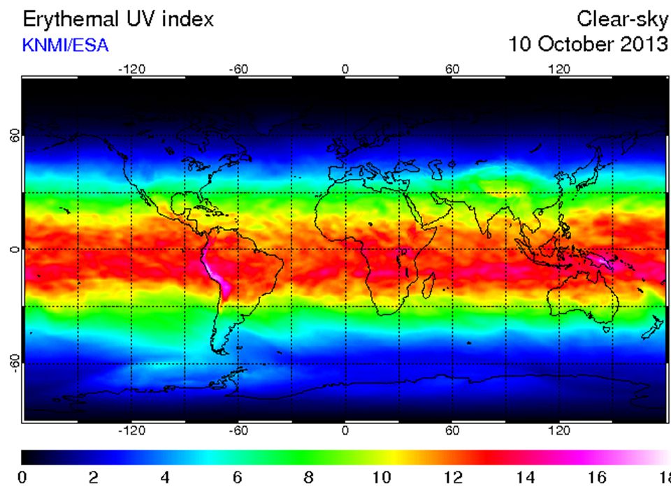
MONITOREO DE LA RADIACION ULTRAVIOLETA

39
Radiación Ultravioleta Diaria PiuraHuancabamba Tumbes

40
PRONOSTICO A OCTUBRE DEL 2013

43
Gracias

Presentaciones similares


 Servicio Meteórologico e Hidrologico Nacional de Belice Guatemala,Guatemala.>")


 and numbers are used to tell time. Copyright © 2008 Vista Higher Learning. All rights reserved.>")


