Descargar la presentación
La descarga está en progreso. Por favor, espere

1
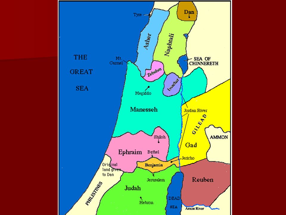
Isaías 9-21

3
Tel Neftali

4
Galilee shoreline from above
Golan Heights Mt. of Beatitudes Capernaum Bethsaida Tabgha Scripture Passages related to Gennesaret Traveling to Bethsaida, Jesus and his disciples were blown off course and landed instead at the region of Gennesaret (Matt 14:34; Mark 6:53). Jesus then healed the multitudes that were waiting there (Mark 6:53-56). The Pharisees and teachers of the law confronted Jesus over ritual impurity (Mark 7:1-23; Matt 15:1-20). The Pharisees and Sadducees came to Jesus asking for a sign (Mark 8:11-13; Matt 16:1-4). Nof Ginosar Galilee shoreline from above
. Jesus then healed the multitudes that were waiting there (Mark 6:53-56). The Pharisees and teachers of the law confronted Jesus over ritual impurity (Mark 7:1-23; Matt 15:1-20). The Pharisees and Sadducees came to Jesus asking for a sign (Mark 8:11-13; Matt 16:1-4). Nof Ginosar. Galilee shoreline from above.")
5
Tabgha aerial from north

7
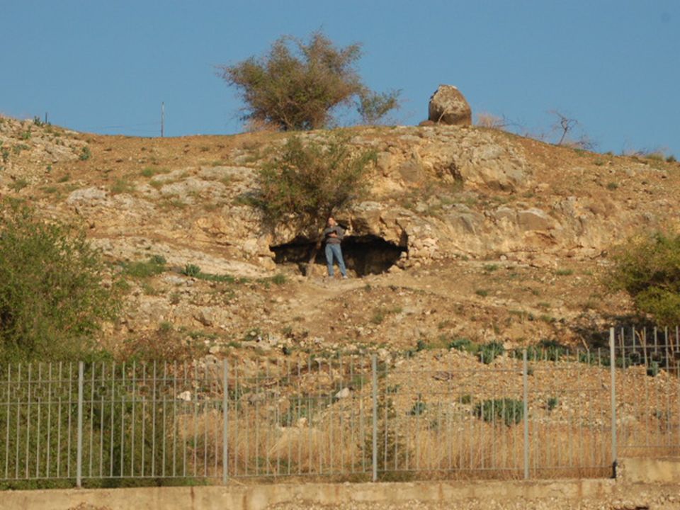
Jesus’ cave, looking toward springs and sunset

8
Jesus’ cave, Via Maris, looking toward Capernaum

9
Capítulo 9 9:1 es 8:23 en hebreo. “livianamente tocaron” (RV) por que es plural en la RV, cuando en hebreo es singular, se refiere a Dios? HIFIL: 1) Hacer que algo sea más liviano, o menos pesado, aligerarlo (1 Rey. 12:10; Jon. 1:5). 2) Tener en poco, tratar con menosprecio. En la NIV, es “humilló”.
 Hacer que algo sea más liviano, o menos pesado, aligerarlo (1 Rey. 12:10; Jon. 1:5). 2) Tener en poco, tratar con menosprecio. En la NIV, es humilló .")
10
Pero ahora “llenará de gloria” (kavod) ¿Cómo mejor llenarlo con gloria que mandar al Rey de gloria para állá? V. 1-2 ver Mat. 4:14-16 El contexto que sigue es de una victoria sobre el reino Madián. Cristo anuncio su reino en Mat. 4:17ss, y será victorioso sobre Satanás y toda la maldad, no solo una nación.

11
v. 6-7 con el NT Lu. 1:32-33, no encaja totalmente
Lo que más encaja es de su reino, la conexión con David, la parte eterna. ¿Será que Lucas les sugiere, (por remez), los otros nombres y/o papeles de Cristo, de Is. 9:6? 6-7 Probable que se refiera a Ezequías, la calidad y duración del reino, especialmente comparado con Acaz. Otro caso de doble cumplimiento? v. 13 volvio, se convirtio, comp ingles y esp. “No ha cesado su furor”, v. 12, 17, 21, 10:4 lo mismo
, los otros nombres y/o papeles de Cristo, de Is. 9:6 6-7 Probable que se refiera a Ezequías, la calidad y duración del reino, especialmente comparado con Acaz. Otro caso de doble cumplimiento v. 13 volvio, se convirtio, comp ingles y esp. No ha cesado su furor , v. 12, 17, 21, 10:4 lo mismo.")
12
Capítulo 10 V 1 hebreo y español mismo versículo otra vez. V Asiria se pone orgulloso, pero Dios está en control de todo, y los usa como herramienta. v Israel se apoyará en El que los hirió, Asiria, y volverá un remanente. V 25, 12:1 el remanante verá el fin del enojo de Dios (ver 9:12, 17, 21, 10:4) vv compara con Rom. 9:27-28 v. 26 dos referencias a los hechos poderosos de Dios, que este será otro.
 vv compara con Rom. 9: v. 26 dos referencias a los hechos poderosos de Dios, que este será otro.")
13
Capítulo 11 El olivero nunca muere; sus raices son profundas. Cada 400 años lo cortan hasta el suelo, y al año siguiente sale una varas. Dios corta a Israel, pero salen varas (choter). Jesús es la ntzer (vastago) (nazareno) de Isaí. Comp con Mat. 2:23 Nuestra fe es como vara que sale de las raices del AT.
. Jesús es la ntzer (vastago) (nazareno) de Isaí. Comp con Mat. 2:23. Nuestra fe es como vara que sale de las raices del AT.")
14
vv ver Apoc. 4:5? Profecía mesianica con acciones que Dios haría. Estas acciones de Dios se delegan a Cristo; por ejemplo, ser juez Juan 5:22 Vv 6-10 Visión del cielo? La creación vuelve a lo que tenia que ser. Comp. con Rom. 8:19-21 v. 10 Compara con Rom. 15:12, 13 Dios de esperanza, Cristo es la esperanza

15
Cap. 12 Capítulo de alabanza
v. 1 finalmente su enojo se va (9:12, 17, 21, 10:4) vv. 4ss Compara con Salmos
 vv. 4ss Compara con Salmos")
16
Capítulo 13 Nueva sección de profecías contra las naciones
Se parece a Apoc. 18 contra Babilonia.

17
Capítulo 14 Favor de Dios para Israel, y burla para el rey de Babilonia y la nación. Hasta los reyes entre los muertos se burlan de ellos. También hay profecías contra Asiria y Filistia.

18
vv. 12-15 suenan como un mito pagano de Siria o Babilonia.
Satanás? Lucas 10:18? Ezequiel 28? Vev helel “el que brilla” Compara con 2 Ped. 1:19

19
Capítulos 15-21 16:1 ¿Quién es la Hija de Sión? Busquen Moab, Nebo, Hesbon, Medeba, Sela, Damasco, Aroer, Ciudad de Herez (Destrucción)—busquen, Asdod Dios responde a Egipto—pasaje de bendición—19:19ss
—busquen, Asdod. Dios responde a Egipto—pasaje de bendición—19:19ss.")
20
Campo de Moab (con Rut)
")
21
Monte Nebo

22
Jericho, Jordan Rift with Mt Hermon aerial from south
Valley of Zeboim Tell Jericho Jericho was one of the earliest inhabited sites because of its strategic location. It guarded three routes into the hill country. The southernmost route is the Ascent of Adumim, which runs along the south side of the Wadi Qilt. To the north ran a route through the Valley of Zeboim, also known as the Way of the Wilderness. The northernmost route ran on a ridge to the village of Ophrah (OT period), Ephraim (NT period; John 11:54) or Taiybe (modern Arab village). Herod’s Palaces Wadi Qilt Cypros Jericho, Jordan Rift with Mt Hermon aerial from south
, Ephraim (NT period; John 11:54) or Taiybe (modern Arab village). Herod’s Palaces. Wadi Qilt. Cypros. Jericho, Jordan Rift with Mt Hermon aerial from south.")
23
Mt Nebo view to Dead Sea Mt Nebo view to Dead Sea
Deuteronomy 34:1-4 (ESV) “Then Moses went up from the plains of Moab to Mount Nebo, to the top of Pisgah, which is opposite Jericho. And the Lord showed him all the land, Gilead as far as Dan, all Naphtali, the land of Ephraim and Manasseh, all the land of Judah as far as the western sea, the Negeb, and the Plain, that is, the Valley of Jericho the city of palm trees, as far as Zoar. And the Lord said to him, ‘This is the land of which I swore to Abraham, to Isaac, and to Jacob, ‘I will give it to your offspring.’ I have let you see it with your eyes, but you shall not go over there.’” Mt Nebo view to Dead Sea
 Then Moses went up from the plains of Moab to Mount Nebo, to the top of Pisgah, which is opposite Jericho. And the Lord showed him all the land, Gilead as far as Dan, all Naphtali, the land of Ephraim and Manasseh, all the land of Judah as far as the western sea, the Negeb, and the Plain, that is, the Valley of Jericho the city of palm trees, as far as Zoar. And the Lord said to him, ‘This is the land of which I swore to Abraham, to Isaac, and to Jacob, ‘I will give it to your offspring.’ I have let you see it with your eyes, but you shall not go over there.’ Mt Nebo view to Dead Sea.")
24
Mt Nebo church Mt Nebo church Mount Nebo
Mt. Nebo is on the edge of the Medeba Plateau. The Nebo ridge has three distinct peaks, all close to one another: Mt. Nebo, the central peak, and Khirbet Mekhayet (“Needle”) to the south. A higher point to the west is called Siyagha (“Monastery”), which is thought to be Pisgah where Moses viewed Canaan and was buried. Mt Nebo church
 to the south. A higher point to the west is called Siyagha ( Monastery ), which is thought to be Pisgah where Moses viewed Canaan and was buried. Mt Nebo church.")
25
Mt Nebo valley to north Mt Nebo valley to north
Moses was buried near Mt. Nebo, possibly at Ein Musa in the valley to the north of Mt. Nebo. Deuteronomy 34:6 (NIV) “He buried him in Moab, in the valley opposite Beth Peor, but to this day no one knows where his grave is.” Mt Nebo valley to north
 He buried him in Moab, in the valley opposite Beth Peor, but to this day no one knows where his grave is. Mt Nebo valley to north.")
26
Mt Nebo looking at Jordan Rift
Deuteronomy 32:49 (NIV) “Go up into the Abarim Range to Mount Nebo in Moab, across from Jericho, and view Canaan, the land I am giving the Israelites as their own possession.” Mt Nebo looking at Jordan Rift
 Go up into the Abarim Range to Mount Nebo in Moab, across from Jericho, and view Canaan, the land I am giving the Israelites as their own possession. Mt Nebo looking at Jordan Rift.")
27
Mt Nebo looking northwest at Jordan Rift
Scripture References to Mt. Nebo in the Time of Moses One of the locations where the Israelites camped (Num 21:20, 27:12; 33:47-48). The area was also called the mountains of Avarim (“across”). Ezekiel 39:11-12 claims that the slain multitudes of Gog are to be buried in the Valley of Avarim, east of the Dead Sea. Pisgah is one of the three heights to which Balak brought Balaam to view and curse Israel (Num 23:11-14; also Bamot Baal, Num 22:41; and Peor, Num 23:28). At that time the Israelites were “encamped on the plains of Moab beyond (i.e., east of) Jordan, opposite Jericho” (Num 22:1-2, 26:63, 33:47-48). Three times from three different peaks of the mountain overlooking the Plains of Moab Balak tried to get Balaam to curse Israel, but all three (or was it four?) times, Balaam blessed Israel instead. Bamoth Baal (Num 22:41) must have been an eastern peak of Nebo since Balaam could only see the farthest edge of Israel’s camp. The steep cliffs of the Rift blocked his view. “How can I curse those whom God has not cursed? How can I denounce those whom the LORD has not denounced?” (Num 23:8, NIV). Zophim, the head of Pisgah, is where he built seven more altars (Num 23:14): “No misfortune is seen in Jacob…the Lord their God is with them…!” (Num 23:21, NIV). Head of Peor (Baal Peor) that looks down on the Jeshimon (Num 23:8). The westernmost of Nebo’s peaks, probably where the monastery is today, is a spot which affords a clear view of the entire Plains of Moab, and Jeshimon, opposite the Dead Sea. Gad and Reuben settled in the regions of Nebo (Num 32:3, 37; Dt 3:17; 1 Chr 5:8). Moses gave to Reuben “the tableland (plateau) of Moab” (Josh 13:16, 21). Mt Nebo looking northwest at Jordan Rift
. The area was also called the mountains of Avarim ( across ). Ezekiel 39:11-12 claims that the slain multitudes of Gog are to be buried in the Valley of Avarim, east of the Dead Sea. Pisgah is one of the three heights to which Balak brought Balaam to view and curse Israel (Num 23:11-14; also Bamot Baal, Num 22:41; and Peor, Num 23:28). At that time the Israelites were encamped on the plains of Moab beyond (i.e., east of) Jordan, opposite Jericho (Num 22:1-2, 26:63, 33:47-48). Three times from three different peaks of the mountain overlooking the Plains of Moab Balak tried to get Balaam to curse Israel, but all three (or was it four ) times, Balaam blessed Israel instead. Bamoth Baal (Num 22:41) must have been an eastern peak of Nebo since Balaam could only see the farthest edge of Israel’s camp. The steep cliffs of the Rift blocked his view. How can I curse those whom God has not cursed How can I denounce those whom the LORD has not denounced (Num 23:8, NIV). Zophim, the head of Pisgah, is where he built seven more altars (Num 23:14): No misfortune is seen in Jacob…the Lord their God is with them…! (Num 23:21, NIV). Head of Peor (Baal Peor) that looks down on the Jeshimon (Num 23:8). The westernmost of Nebo’s peaks, probably where the monastery is today, is a spot which affords a clear view of the entire Plains of Moab, and Jeshimon, opposite the Dead Sea. Gad and Reuben settled in the regions of Nebo (Num 32:3, 37; Dt 3:17; 1 Chr 5:8). Moses gave to Reuben the tableland (plateau) of Moab (Josh 13:16, 21). Mt Nebo looking northwest at Jordan Rift.")
28
Mt Nebo view of plains of Moab and Dead Sea
Later Historical References to Mt. Nebo Mesha Stele, lines “Chemosh said to me ‘Go! Take Nebo against Israel.’ And I went by night and fought against it from break of dawn till noon...” “Woe to Nebo for it will be ruined” (Jer 48:1, NIV; cf. Isa 15:2). Second Maccabees 2:4-8 alleges that Jeremiah hid the Tabernacle, Ark of Covenant and altar of incense in a cave on Mt. Nebo, before the Babylonians destroyed the Jerusalem Temple. “Only the Lord will disclose its location” (2 Macc 2:8). Mt Nebo view of plains of Moab and Dead Sea
. Second Maccabees 2:4-8 alleges that Jeremiah hid the Tabernacle, Ark of Covenant and altar of incense in a cave on Mt. Nebo, before the Babylonians destroyed the Jerusalem Temple. Only the Lord will disclose its location (2 Macc 2:8). Mt Nebo view of plains of Moab and Dead Sea.")
29
Tell Hesban view of Medeba Plateau
Introduction Tell Hesban is 895 m above sea level. Tell Hesban is a sizeable 50 acre tell that dominates the Medeba Plateau. It has 19 strata, dating from 1200 B.C. to 1500 A.D. The tell is 12 mi southwest of Amman, 35 mi east of Jerusalem, and 6 km northeast of Mt. Nebo. The Search for Heshbon "The first archaeologists to explore [Tell Hesban] include John Garstang (1931), Nelson Glueck (1933), and Bernhard Anderson (1963); all assumed it to be the biblical Heshbon" (Geraty 1997: 19). “The disappointing discovery that at Tell Hesban no traces of any pre-12th-century settlement could be found provided further incentive…to begin exploration of other sites in the vicinity of Tell Hesban. By means of the regional survey it was hoped that other sites might be identified where traces of the elusive Late Bronze Age occupants of this region might be found” (O. LaBianca [in R. D. Ibach Archaeological Survey of the Hesban Region (Hesban 5). Berrien Springs, MI: Andrews University] cited in Finkelstein 1998: 121). After this disappointing series of digs, the Madaba Plains Project was formed and the search for Heshbon continued. Four Late Bronze sites were found within a 6 mi radius of Hesban; Tel Jalul is the biggest and thus the most promising site. Jalul is the largest site in Jordan south of Amman. Three possibilities exist for biblical Heshbon: Tel Hesban, Tel el-Umeiri, and Tel Jalul. Hesban preserves the name, which makes it a good candidate, but it lacks the archaeological evidence. The Hesban survey covered circa 250 sq km (a radius of 10 km around Tell Hesban), took 5 months over a 3 year period, and was conducted by 4-5 surveyors. The goal was to record all discovered antiquities, and included: 155 sites recorded, 52,000 sherds collected (half from Tell Jalul – the second most important site in the area). The researchers were hoping that Jalul would solve the problem of the lack of Late Bronze material at Hesban (Finkelstein 1998: ). “I wish Professor Horn well in his research elsewhere for this site [that of biblical Sihon], which must surely be in the region of modern Hesban. I sometimes wonder if earlier biblical scholars have not made life more difficult for their successors by their enthusiasm for equating modern sites with biblical ones and suggesting to the present-day villagers the ancient name. This, with the Arabs’ phenomenal memory, is remembered for perhaps more than 20 years and coupled with the Arabs’ ingrained desire to please their guests, what was a suggestion a decade or so earlier, becomes a fact. (The writer had exactly this problem with the equation of Umm el-Biyara with biblical Sela by the local tribe, though it must be confessed they were not quite sure what biblical Sela was)” (Bennett 1986: 75). Iron Age Archaeological Finds “The Iron Age remains are very fragmentary as a result of periodic removals of earlier strata on top of the hill by later builders; nevertheless, evidence for at least four strata remains” (Geraty 1997: 20). The pottery from the Medeba Plains Plateau closely resembles that of the central hill country north of Jerusalem in the Iron I Period (Sauer 1994: 237; Finkelstein 1996: 200; 204; Sauer and Herr 1997: 234). The Late Iron Age town appears to have come to a sudden, violent end, sometime during the fifth century B.C. Thereafter it was left in a state of abandonment for nearly three centuries. The evidence for this is the absence of any significant quantities of Late Persian and Early Hellenistic remains. Another evidence is the large quantities of ash in the debris scraped from the abandoned Late Iron Age town into the reservoir by later rebuilders of the second century B.C. Tell Hesban view of Medeba Plateau
, Nelson Glueck (1933), and Bernhard Anderson (1963); all assumed it to be the biblical Heshbon (Geraty 1997: 19). The disappointing discovery that at Tell Hesban no traces of any pre-12th-century settlement could be found provided further incentive…to begin exploration of other sites in the vicinity of Tell Hesban. By means of the regional survey it was hoped that other sites might be identified where traces of the elusive Late Bronze Age occupants of this region might be found (O. LaBianca [in R. D. Ibach Archaeological Survey of the Hesban Region (Hesban 5). Berrien Springs, MI: Andrews University] cited in Finkelstein 1998: 121). After this disappointing series of digs, the Madaba Plains Project was formed and the search for Heshbon continued. Four Late Bronze sites were found within a 6 mi radius of Hesban; Tel Jalul is the biggest and thus the most promising site. Jalul is the largest site in Jordan south of Amman. Three possibilities exist for biblical Heshbon: Tel Hesban, Tel el-Umeiri, and Tel Jalul. Hesban preserves the name, which makes it a good candidate, but it lacks the archaeological evidence. The Hesban survey covered circa 250 sq km (a radius of 10 km around Tell Hesban), took 5 months over a 3 year period, and was conducted by 4-5 surveyors. The goal was to record all discovered antiquities, and included: 155 sites recorded, 52,000 sherds collected (half from Tell Jalul – the second most important site in the area). The researchers were hoping that Jalul would solve the problem of the lack of Late Bronze material at Hesban (Finkelstein 1998: ). I wish Professor Horn well in his research elsewhere for this site [that of biblical Sihon], which must surely be in the region of modern Hesban. I sometimes wonder if earlier biblical scholars have not made life more difficult for their successors by their enthusiasm for equating modern sites with biblical ones and suggesting to the present-day villagers the ancient name. This, with the Arabs’ phenomenal memory, is remembered for perhaps more than 20 years and coupled with the Arabs’ ingrained desire to please their guests, what was a suggestion a decade or so earlier, becomes a fact. (The writer had exactly this problem with the equation of Umm el-Biyara with biblical Sela by the local tribe, though it must be confessed they were not quite sure what biblical Sela was) (Bennett 1986: 75). Iron Age Archaeological Finds. The Iron Age remains are very fragmentary as a result of periodic removals of earlier strata on top of the hill by later builders; nevertheless, evidence for at least four strata remains (Geraty 1997: 20). The pottery from the Medeba Plains Plateau closely resembles that of the central hill country north of Jerusalem in the Iron I Period (Sauer 1994: 237; Finkelstein 1996: 200; 204; Sauer and Herr 1997: 234). The Late Iron Age town appears to have come to a sudden, violent end, sometime during the fifth century B.C. Thereafter it was left in a state of abandonment for nearly three centuries. The evidence for this is the absence of any significant quantities of Late Persian and Early Hellenistic remains. Another evidence is the large quantities of ash in the debris scraped from the abandoned Late Iron Age town into the reservoir by later rebuilders of the second century B.C. Tell Hesban view of Medeba Plateau.")
30
Tell Hesban view to Jordan Rift
Scripture References to Heshbon There are 38 biblical references to Heshbon. “Israel took all these cities, and Israel settled in all the cities of the Amorites, in Heshbon, and in all its villages. For Heshbon was the city of Sihon, king of the Amorites, who had fought against the former king of Moab and taken all his land out of his hand, as far as Arnon” (Num 21:25-56, ESV; cf. Dt 2:26-37). Moses recounted the battle the Israelites had with Sihon of Heshbon (Dt 2:26-37). Gad and Reuben rebuilt and settled in Heshbon (Num 32:34-37; Josh 21:38-39). Heshbon was designated as a Levitical city in the territory of Gad (Josh 21:34-40). After the death of Solomon, the Northern Kingdom was able to secure control of the Heshbon/Medeba region. But within a hundred years, Moab was expanding north of the Arnon to these regions. This is reflected archaeologically (see Mesha Stele) and biblically in Isaiah and Jeremiah (Isa 15:2-4; 16:9; Jer 48:1-2). Tell Hesban view to Jordan Rift
. Moses recounted the battle the Israelites had with Sihon of Heshbon (Dt 2:26-37). Gad and Reuben rebuilt and settled in Heshbon (Num 32:34-37; Josh 21:38-39). Heshbon was designated as a Levitical city in the territory of Gad (Josh 21:34-40). After the death of Solomon, the Northern Kingdom was able to secure control of the Heshbon/Medeba region. But within a hundred years, Moab was expanding north of the Arnon to these regions. This is reflected archaeologically (see Mesha Stele) and biblically in Isaiah and Jeremiah (Isa 15:2-4; 16:9; Jer 48:1-2). Tell Hesban view to Jordan Rift.")
31
Ciudad fortaleza de Edom, Sela, hoy Umm el-Biyara

32
Nahal Arnon (cruzada?)
")
33
View east from Aroer with ruins in foreground

34
Valle de Refaim

35
El desierto de Egipto y el Nilo

36
Nile River Valley Nile River Valley
99% of the population of Egypt today lives in the Nile River Valley. Nile River Valley

37
Lean Is. 15-21 Nile River Valley
99% of the population of Egypt today lives in the Nile River Valley.

Presentaciones similares


 29 de julio de 2004.>")


